
Majority on Oviedo City Council favor scaling back density increase in Comp Plan proposal
Half a dozen Oviedo residents voiced opposition to the city’s proposed Comprehensive Plan update that would increase the density on land within the Mitchell Hammock corridor during a City Council work session on Monday night.
“Tonight’s the first night. We’ll keep coming and we’ll show our support to keep the Comp Plan the way it is,” said Belinda Ewen, a resident at Kingsbridge West in Oviedo, which sits off of East Mitchell Hammock Road.
The city is in the process of creating an update to its Comprehensive Plan – a document that’s updated every decade. The city must take the state’s population projections – an increase of 20,000 residents by 2045 – to lay out an intention for future development and land use so the city can ensure those residents, plus current residents, have ample places to live, enough amenities such as restaurants, entertainment and schools, and sufficient city services such as water, sewer and police and fire protection. It also considers roads, environmental protections and financial sustainability.
Monday night’s meeting was an information session for the Council, and the discussion mostly focused on the update’s shift in building density from the suburban areas to the city’s downtown core, which includes Oviedo on the Park, the historic downtown, the Oviedo Mall area and the Mitchell Hammock corridor. That means that high-density projects – those that include multi-family housing, such as apartments and townhomes, and commercial space, such as shops, restaurants and offices – will be largely relegated to these areas.
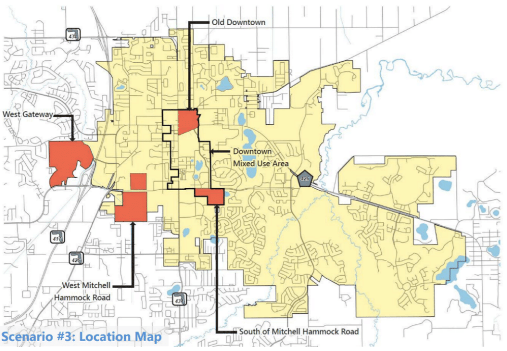
In order to gather public input, the consultant the city hired to work on the Comprehensive Plan, Vanasse Hangen Brustlin, had three groups put circles on the map showing where they wanted density to go in a visioning workshop last summer. Two of the groups were made up of residents and one was made up of land owners. In the Mitchell Hammock corridor, the resident groups wanted lower density while the land owner group wanted higher density.
All of the residents who spoke at the meeting were there for the Mitchell Hammock corridor. The 214-acre area is currently a mix of zonings, including commercial land, agricultural land (which is mostly A. Duda & Sons sod farms) and rural land. The proposed update would increase the residential allotment on parts of the Mitchell Hammock corridor land to a maximum of 30 residential units per acre (or 50 if it’s developed vertically or as mixed-use).
With bonuses, a maximum of 100 residential units/acre could be built there. A developer can get bonuses if they meet certain criteria, such as including affordable housing, green building or open space. Even if they include such things, bonuses are subject to negotiation with city staff and no developer has ever applied for them.
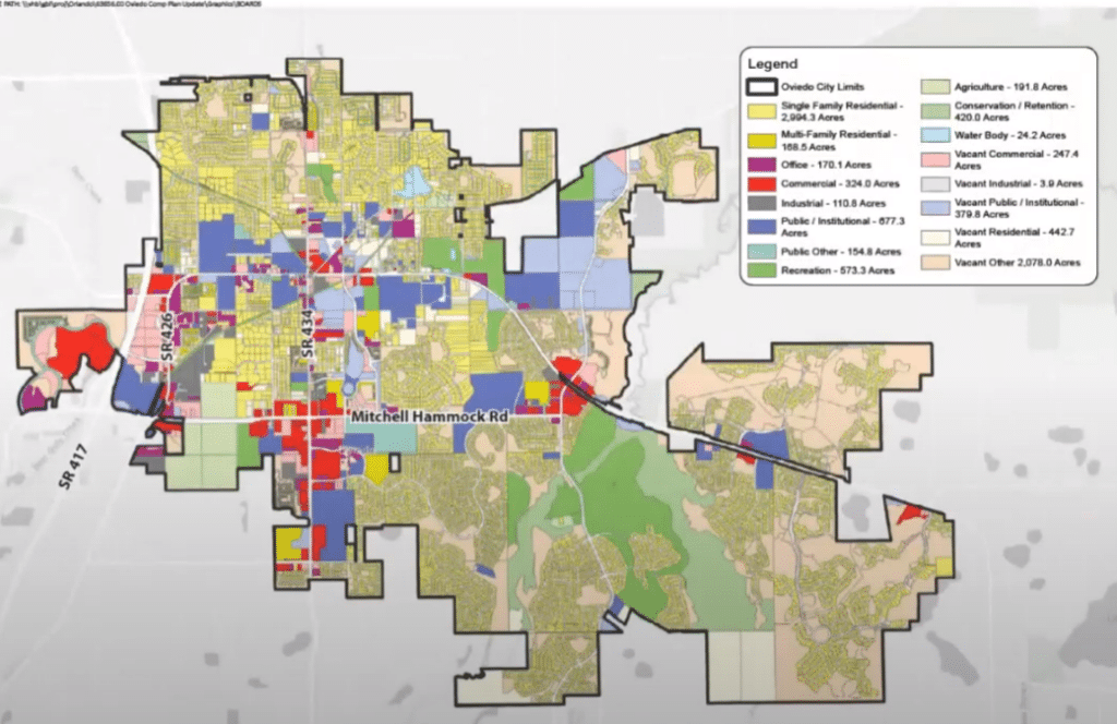
This is a map with the current land uses:
Resident Pam Smith said that when this issue of density change in the area was considered years ago, she and her neighbors collected 3,000 signatures in opposition. Smith was particularly concerned with the 40 acres, currently zoned rural, which the city leases for its percolation ponds and abuts the Kingsbridge West and Alafaya Woods neighborhoods.
“Our city and our roads are not ready for this and as Council members who were elected by the people, please hear us,” she said. “We’ll get [the signatures] again if we need to because the same people are out there if not more.”
Several Council members discussed possible changes to the density proposed for the Mitchell Hammock corridor.
“I think the extent we’ve done here is more than I’m comfortable with, especially the sod farm areas and the perc [percolation] ponds,” said Councilwoman Natalie Teuchert. “Mitchell Hammock is not ready for this.”
Both Mayor Megan Sladek and Deputy Mayor Bob Pollack suggested scaling the proposed future use in the area to transitional downtown instead of downtown core.
Here’s a graphic explaining the different land uses. The dark brown is Downtown Core and the light brown is Downtown Transition.
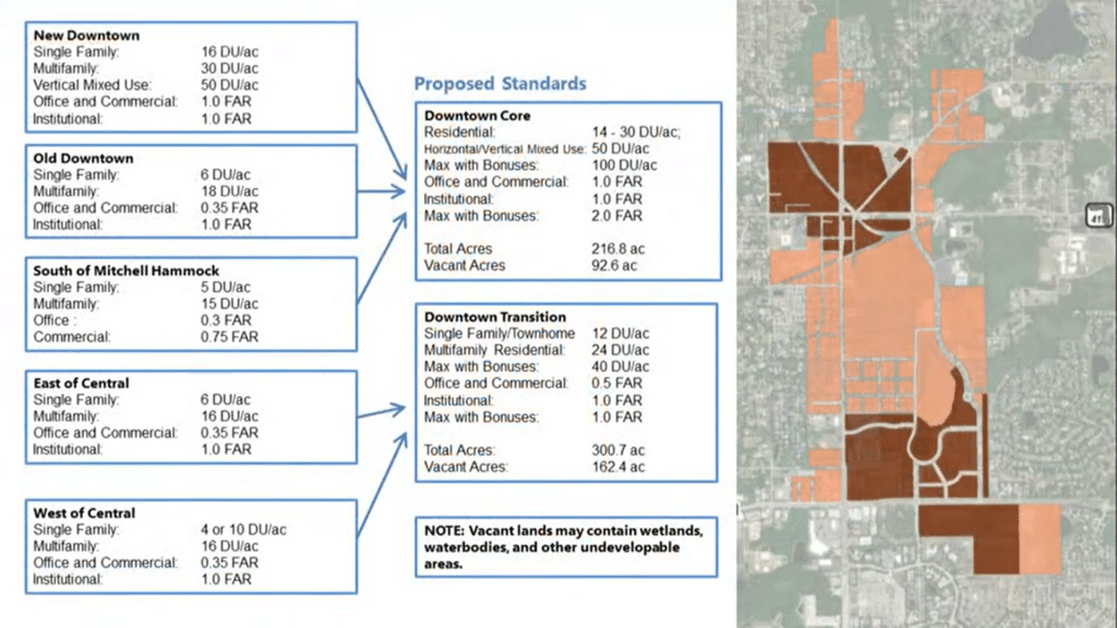
According to Curtis Ostrodka, director of planning for VHB, the dark brown area is meant to be the most intense density in the city.
“It will be the central business district so it would have the tallest buildings, the most residents in it and the best civic amenities,” he said. “This is where people would gather. It’s a great place to walk, shop, and bicycle to and from. You may not need to own a car if you live here. It would discourage automobile-oriented uses so you would not likely see drive-throughs or large parking lots in the core. You probably all have a favorite city that you get out and walk around in. This is the intent.”
Sladek asked staff to create transition areas between the sections of the proposed downtown core that do not have them (on the map above, the areas where the dark brown is not surrounded by light brown). She said not doing so would be unfair to residents who did not sign up to live next to high density when they moved there.
Teuchert said she thinks that creating so many urban areas throughout the city would not achieve the dedicated downtown core that’s desired.
“I think we’re definitely trying to do the right thing here. We’re developing our core areas. What I’m concerned about is that we’re biting off more than we can chew.”
Councilman Jeff Boddiford said he would keep the proposed update as is. He said most of the traffic issues are coming from outside of the city, which is out of Oviedo’s control.
“It’d be nice if there was something built at some point that could actually help relieve that but that’s outside of our control,” he said.
Filling money gaps
The city’s purpose behind building density in core areas is not only to provide for future population growth, it’s also a way to build its tax base.
Consultant Urban3 LLC told the city last year that Oviedo’s revenues reflect a $15 million annual budget shortfall based on the amount of money it would take to maintain its current infrastructure (roads, water, sewer).
The Urban3 report showed that multi-family housing generated double the tax revenue per acre as commercial and single homes; that Oviedo on the Park produced the most property tax revenue compared to other areas in the city; and that denser development led to lower infrastructure costs per person.
Another solution the consultant discussed was raising taxes. A possible fire tax is currently being proposed for the city and a water rate hike was approved in January.
All about the roads
The discussion about how densely to develop the Mitchell Hammock corridor kept leading to a discussion about congestion on Mitchell Hammock Road.
“People are taking so many chances on [Mitchell Hammock] just trying to get through,” said resident Susan Goldman. “I fear for my life every day. It’s bottlenecked morning, noon and night. I don’t know how you plan on doing all this without giving us more roads.”
The possibility of adding a stipulation that road capacity must be dealt with before a developer can build was discussed.
“Having it in the plan is better because it gives us something that when we’re negotiating with developers, we can say, ‘this is something we’re planning for and we want you to help with this. With it in the plan we can require it of them,” City Manager Bryan Cobb said.
Cobb said the main issue with Oviedo’s traffic is that most of it funnels through only two intersections: County Road 419 and Lockwood Boulevard and State Road 426 and Mitchell Hammock Road. S.R. 434 and Mitchell Hammock Road is another busy intersection.
Cobb said the remedy is to “create as many opportunities as possible in the network so not all the traffic is concentrated in a few roadways.”
Several connections were discussed during the meeting, including extending Oviedo Boulevard to Alexandria Boulevard, and connecting Slavia Road to Alafaya Woods Boulevard and to State Road 417.
VHB’s consultants said that Oviedo grades its roads on a daily basis, meaning that it looks at total daily traffic numbers on road, not the number at peak traffic times, to determine if they’re at capacity. This is why most roads still show they have capacity for growth even though motorists experience a lot of congestion.
As the city works through this Comprehensive Plan update, it’s also updating its 10-year Mobility Plan, which prioritizes projects and programs based on data, analysis and public input gathered during the Comprehensive Plan update process. An autonomous vehicle circuit connecting the different urban cores is expected to be discussed. A work session on this plan is scheduled for March 30.
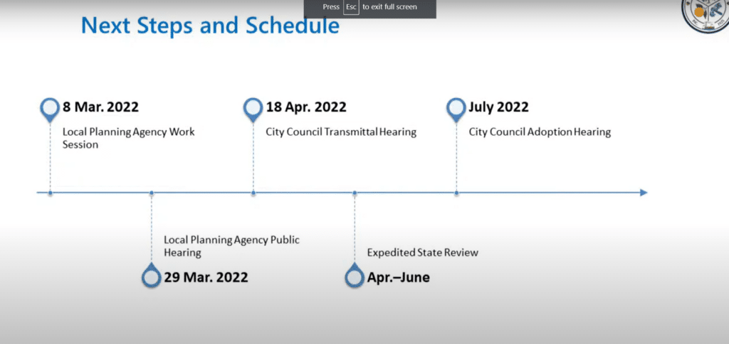
Future meetings
The next stop for the Comprehensive Plan update is another informational session at the Local Planning Board meeting on March 8. City staff is expected to incorporate the City Council suggestions from Monday night’s meeting for that session.
At the LPA’s March 29 meeting, the board is expected to make their recommendations to the Council. At a April 18 hearing, the City Council is expected to submit the update to the state for review. The state’s review of the update could take several months to complete. The city expects that to be complete by June.
Watch the City Council’s discussion of the Comprehensive Plan updates:
Sorry for the interruption but please take 1 minute to read this. The news depends on it.
Did you know each article on Oviedo Community News takes anywhere from 10-15 hours to produce and edit and costs between $325 and $600? Your support makes it possible.
We believe that access to local news is a right, not a privilege, which is why our journalism is free for everyone. But we rely on readers like you to keep this work going. Your contribution keeps us independent and dedicated to our community.
If you believe in the value of local journalism, please make a tax-deductible contribution today or choose a monthly gift to help us plan for the future.
Thank you for supporting Oviedo Community News!
With gratitude,
Megan Stokes, OCN editor-in-chief
Thank you for reading! Before you go...
We are interested about hearing news in our community! Let us know what's happening!
Share a story!
Author

Related Articles
DeSantis vetoes Seminole County appropriations worth $2.5M
Projects included a smart water meter system upgrades, an AI system to monitor schools for guns and crosswalk projects, but were vetoed by DeSantis.
City of Oviedo plants Liberty Tree as part of America’s 250th anniversary celebration
Newly planted hickory tree is one of seven planned Liberty Trees across Seminole County to commemorate semiquincentennial.
Oviedo begins preparing for potential property tax vote impact
“There are places in this state, cities that will probably not continue to exist,” Seminole County Property Appraiser Johnson said.